News
-
IPMA represented in Rennes
-
IPMA hosts training session
-
IPMA present at the project launch


GEOMAGNETISM
Geomagnetism
One of the tasks of IPMA is to ensure the functions of national authority in the field of geomagnetism.
The Department of IPMA it guarantee the observation of the geomagnetic field, for it must ensure the functioning of the magnetic network of fixed and mobile stations, as well as develop and disseminate appropriate information.
The Earth's Magnetic Field
The earth we live in has a magnetic field and the effects of its existence was already known to the ancient Chinese civilization and was also used for guidance at the time of discovery. In his book From Magnet, 1600 Gilbert considered for the first time that the Earth behaved himself as a gigantic magnet permanent.
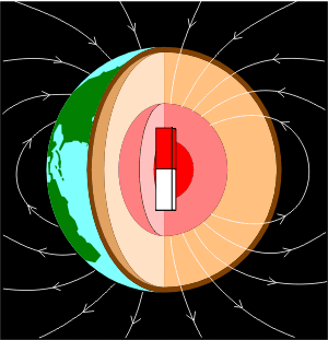
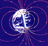
The terrestrial magnetic field is so similar to a magnetic dipole and can be viewed in terms of a set of lines of force leaving from one end of the magnet, called North Pole and returning the other end, the south pole. The axis of this dipole magnet is an angle of about 11 of the axis of rotation of the Earth.
 |
 |
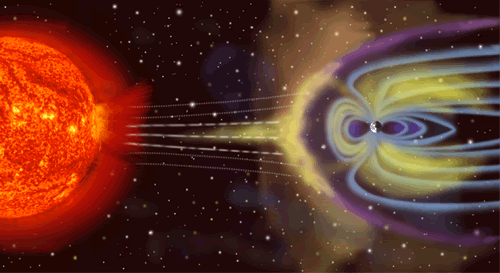
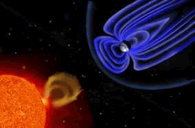
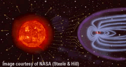
The magnetic field of this dipole, from inside the Globe, explains about 90% of the total magnetic field land. The rest comes from abroad, such as activity of the sun on the ionosphere and magnetosphere.
Despite the Earth's magnetic field opinion to the field generated by a magnet, this may not be the explanation for the origin of the field. In fact the magnetic properties of materials are not standing for temperatures above the point of Curie. And the knowledge of the spread of seismic waves from earthquakes, we know that the Earth's outer core is liquid, thus presenting their materials (iron and nickel) temperatures higher than the corresponding points of Curie.
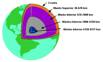 |
The most plausible explanation now is to understand how our generated magnetic field, is the theory of Dínamo. The movement of fluid good driver (mainly iron in the liquid state) in the outer core, caused by Earth's rotation and by convection currents of, generates electric currents and consequently a magnetic field.
 |
|
 |
 |
The terrestrial magnetic field is a vector with character, that is at every point in space has a direction and a dimension.
To describe clearly the field three quantities are needed, such as:
- the intensity of three components orthogonal (X, Y and Z) or
- the intensity of the total field and two angles (A, D and I) or
- the intensity of two components and an angle (H, Z and D).
At any point of view, is used in a reference Cartesian directions in which the X and Y are respectively coincide with the parallels and meridians geography. The Z direction is aligned upright. Once we have that:
|
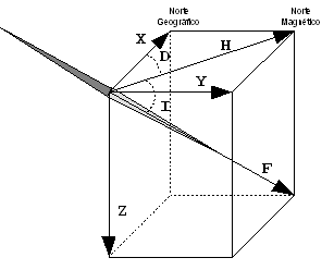 |
The other components are measured in 'nanotesla' (nT, 1 nT = 10-9Tesla = 10-5Gauss).
The seven elements that characterize the terrestrial magnetic field can be expressed mathematically as follows.
| D=arctan(Y/X) | I=arctan(Z/H) | H=((X2+Y2))½ | X=H.cos(D) | Y=H.sen(D) | F=((X2+Y2+Z2))½ |
The intensity of the total field (F) varies from about 24 000 nT in an area of South America and about 66 000 nT in an area between Antarctica and Australia. In continental Portugal and the Azores archipelago currently varies around the 44 000 nT, in the archipelago of Madeira at around 40 000 nT.
If we let fluctuate freely the needle of a compass, it will be positioned vertically a point near the North Pole and another near the South Pole The point of these is the name of magnetic north pole and south magnetic pole respectively. The same needle will be parallel to the land surface in areas near the equator. In such places, where the angle is 0 °, we have the magnetic equator.
So the inclination (I) varies between -90 ° in the south magnetic pole and 90 of the magnetic north pole, and in Continental Portugal and the Azores around the 54 and Madeira around 45.
The Declination (D) in the mainland is around 4 ° W (magnetic north is for the North West geographical, or is negative). In the archipelagos of Madeira and the Azores respectively round 6 of W and 12 W.
The magnetic field in addition to not be uniform, suffers variations in time. These variations may be short on time or for long periods. The former are mainly derived from solar activity and its interaction with the Earth's ionosphere and magnetosphere. Examples are the daily variations, the magnetic storms (which may give rise to the auroras boreal), the magnetic pulses, and so on. At Slower variations that have their origin in the outer core gives up the name of secular change.
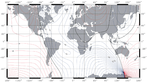 Magnetic declination for 2005 |

-
Lisboa:
UTC:
Copyright © Portuguese Institute for Sea and Atmosphere 2026
-
