SAT TOPAS campaign
 2020-10-13 (IPMA)
October 22, 2020 (update):
SAT TOPAS oceanographic campaign - Acceptance tests for the TOPAS PS120 sub-fund profiler
The acceptance tests of the seabed profiling equipment (TOPAS PS120) to be acquired by IPMA, took place from 15 to 18 October through the C4G project (Collaborative for the Geosciences of the National Roadmap for Strategic Research Infrastructure of Interest (RNIE) the Foundation for Science and Technology and the European Regional Development Fund (POCI-01-0145-FEDER-022151).
The bottom profiler was tested simultaneously and successfully with the Teledyne-Reson T50-P multibeam echo probe (figure 2) mounted on a side pole on the port side of the Diplodus N / I. The support for the two devices was designed and developed under the MINEPLAT project (ALT20-03-0145-FEDER-000013), and a patent application was submitted to the European Patent Office. The technical design of the support was carried out by the IPMA team and the hydrodynamics studies, in order to guarantee the absence of interference between the two equipment, were carried out by CEIIA.
Due to the poor state of the sea, the tests were carried out in the estuary and at the mouth of the Tagus river and in the terminal part of it, as shown in figure 3.
The IPMA Reson T50-P multibeam system was operated simultaneously with the TOPAS 120 bottom profiler, to acquire bathymetry and acoustic back-dispersion data. The new high resolution mode (1024 beams) was tested with good results, both for the definition of the bottom morphology and for the detection of debris as shown in figure 4.
The record obtained with the bottom profiler (figures 5 and 6) showed good results, especially in favorable sea conditions and in bottoms with fine sediments (silts, silt).
October 13, 2020
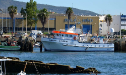
SAT TOPAS campaign took place between 1st to 5th October 2020, aboard IPMA´s Research Vessel Diplodus (figure 1). SAT is the english acronym for Sea Acceptance Trials, wish is an equipment acceptance tests under typical operating sea conditions.
TOPAS PS129 equipment is a sub-bottom profiler suitable for areas between ~ 2 m to ~ 400 m of the water column depth. The sub-bottom tillers aim at sedimentary discrimination in the aquatic bottom first meters with vertical centimeter resolutions. These systems can be applied to geological exploration and can be used to detect geological or artificial objects buried at shallow depth. For example, detection of active failures, mineral deposits, tsunamis or storms, sunken ships, etc.
Figure 8, taken from the publication Mil-Homens et al. (2020) shows the acoustic register greater detail from the image above (acoustic profiler) compared to the one below (very high resolution reflection seismic). This large vertical resolution is used to distinguish objects buried at shallow depths or mineral deposits, such as sand for beach feeding.
The technical team had 3 IPMA technicians, 1 supplier company member (3P) and 1 manufacturer member (Kongsberg).
Test area was located at Tagus River mouth, where IPMA has already carried out other types of surveys using other acoustic methods (figure 7).
Bibliography:
Mário Mil-Homens, Pedro Brito, Vitor Magalhães, Marcos Rosa, Marta Neres, Marta Silva, Emília Salgueiro, Teresa Drago, AnaIsabel Rodrigues, Miriam Tuaty Guerra, Maria José Gaudêncio, Eveline Almeida, Mariana Silva, Mafalda Freitas, Celso Aleixo Pinto, Cidália Bandarra and Pedro Terrinha (2020). Integrated geophysical and sedimentological datasets for assessment of offshore borrow areas: the CHIMERA project (western Portuguese Coast). In, Asch, K., Kitazato, H. and Vallius, H. (eds) From Continental Shelf to Slope: Mapping the Oceanic Realm.Geological Society, London, Special Publications, 505, https: //doi.org/10.1144/ SP505-2019-100
Imagens associadas
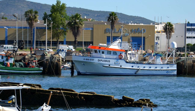
Figure 1- IPMA Research Vessel “Diplodus”

Figure 2- Left: Mounting the TOPAS PS120 bottom profiler. In the image the technicians of IPMA, Kongsberg (manufacturer) and supplier (3P consultants). Right: pole mounted with multi-beam echo sounder on top and bottom profiler on bottom
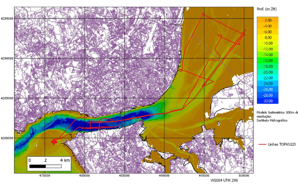
Figure 3- Navigation lines carried out during the sea tests of the TOPAS PS120 bottom profiler
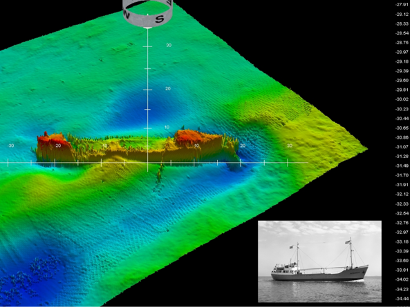
Figure 4-Screen copy image, unprocessed data from a ship sunk in the Tagus river obtained by the multibeam rig. Bottom right, Archive photo of the ship (“Pegasus”, 46m, sunk in 1966).
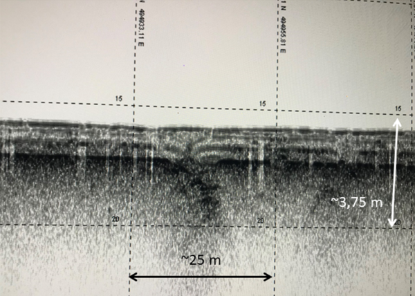
Figure 5- Screen copy, raw data from TOPAS PS120 bottom profiler obtained from the Tagus River. Note the presence of “multiple” of the bottom (with a double slope of the real and the two sedimentary units visible in the acoustic register. The image, still unprocessed, shows the high resolution possible with the profiler, in the order of the decimeter.

Figure 6- Image, screen copy, raw data from TOPAS PS120 bottom profiler obtained from the Tagus River. Note the disruption of recent sediments possibly due to a seismic event.
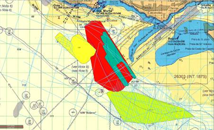
Figure 7- TOPAS PS120 equipment test area (Tagus river mouth)
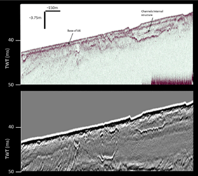
Figure 8- Same zone image comparison obtained through (top) bottom profiler and (bottom) very high resolution reflection seismic. Taken from Mil-Homens et al. (2020). Note the great definition above the superficial sediments layers in detriment of lower ones due to energy loss

-
Lisboa:
UTC:
Copyright © Portuguese Institute for Sea and Atmosphere 2026
-
