Iberian Margin Observatory
![]() 2025-06-06 (IPMA)
2025-06-06 (IPMA)
The Iberian Margin Regional Facility (IbMa-CSV) was anchored again on 24 May 2025 in the Algarve.
The facility was anchored around 20 km south of Sagres, is the responsibility of IPMA and the Algarve Sea Science Centre (CCMAR,) and aims to gather data on the long-term evolution of the ocean's surface structure, in the context of climate change.
The infrastructure is located on a Title of Private Use of Maritime Space (TUPEM) on the edge of the continental shelf, at a depth of 200 metres. The area where it is located is very important for studying and predicting natural disasters or geological events, such as the great Lisbon earthquake of 1755 and its tsunami. It is also an area where the Atlantic Ocean and the Mediterranean Sea meet, with the waters coming off the Mediterranean Sea at intermediate levels, playing a fundamental role in the balance of salt and heat in the northern Atlantic Ocean and in the Atlantic Meridional Overturning Circulation (AMOC).
The Iberian Margin is also the northern region of the productive Canary Current Upwelling System, one of the ocean's four Eastern Boundary Upwelling Systems, where a highly variable upwelling regime predominates, along with strong mesoscale activity. The geological and oceanographic characteristics of this region favour the presence of large populations of small pelagics, highly diverse benthic communities that also play a central role in the distribution of various species of marine mammals and fish.
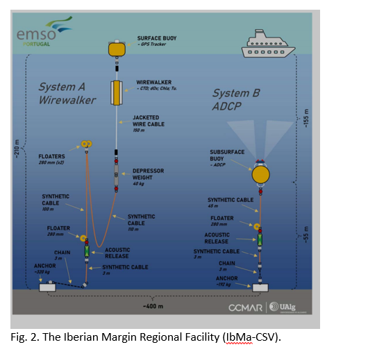
The infrastructure consists of a wave-powered vertical profiler (Wirewalker) and an acoustic Doppler current profiler (ADCP) (Fig. 2). The Wirewalker measures temperature, salinity (conductivity), pressure, dissolved oxygen, chlorophyll-a and turbidity in the water column at very high frequency. The ADCP measures the speed and direction of the current in the first 150 metres. This mooring will be collected in 4 to 5 months, extending an existing time series of observations at the same location. It is intended that this infrastructure will be permanently maintained in the future, only interrupted for short periods for maintenance or equipment replacement, within the scope of EMSO.PT, the national contribution to EMSO-ERIC.
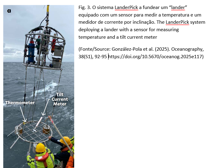
As part of the ‘Low-cost landers for complementary sustained near-bed monitoring at EMSO deep sites (LOCOLAND)’ project, funded by the EMSO/ERIC Physical Access Programme, two landers were also launched with the LanderPick system (Fig. 3). LOCOLAND is a collaboration between the IEO, IPMA and CCMAR and is part of a wider cooperation under the Atlantic Arc Lander Monitoring Programme (ALaMo), in which the Marine Institute of Ireland also participates (see article González-Pola et al., 2025, attached).
It is also important to note that this anchoring was carried out from the Spanish oceanographic ship Angeles Alvariño, operated by the Spanish Institute of Oceanography (IEO), taking advantage of the ship's transit between Vigo and Cádiz. IPMA would like to thank all the Spanish crew, technicians and scientists involved for their excellent collaboration, but especially Dr César González-Pola and Dr Ricardo Sanchez from the IEO.
Imagens associadas


IPMA logo

-
Lisboa:
UTC:
Copyright © Portuguese Institute for Sea and Atmosphere 2026
-
