Turquey Earthquake Update
 2023-02-08 (IPMA)
February 8, 2022 - Information updated
On February 6, 2023, two major earthquakes hit the region between Turkey and Syria.
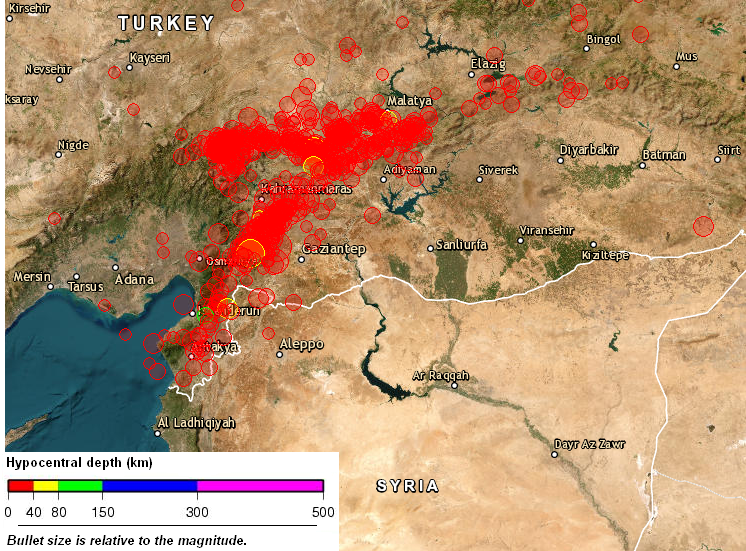
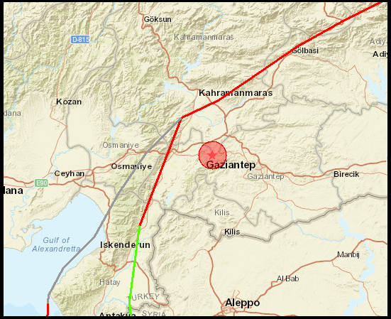
The first, at 01:17 UTC, with magnitude Mw7.8 [Mw- moment magnitude], occurred about 30 km from Gaziantep (latitude 37.174°N and longitude 37.032°E), at a depth of 18 km. This earthquake is located in the intersection of two transform faults, the Dead Sea Fault, oriented north-south to northeast-southwest, and the East Anatolian Fault, oriented east-west. The first separates the African and Eurasian Plates from Arabia (Asia) and the second establishes the southern boundary of the Anatolian Plate (Turkey). These two faults intersect forming a triple point on the Earth's surface, in this case a T-T-T (transform-transform-transform) triple junction.
About 9 hours later, at 10:24 UTC, a second earthquake of magnitude Mw7.5 (latitude 38.024°N and longitude 37.203°E) occurred on the East Anatolian Fault, 4 km southeast of the town of Ekinözü, and about 90 km north of the first event, with a depth of 10 km. Given that the two faults are different tectonic structures, well identified and very old, the second earthquake is not considered an aftershock of the first, but a new large earthquake probably resulting from the adjustment of forces causing from the release of energy and deformation of the first. The Anatolian (Turkey) plate is a block of continental crust whose movement is westward, this expulsion results from the general north-south compression of the region.
Both earthquakes resulted from a strike-slip mechanism and according to the United States Geological Survey (USGS), the rupture length is approximately 190 km and 120 km for the two events, respectively. Both earthquakes were felt with a maximum intensity of IX (USGS), which represents a vibration level classified as violent with very significant potential damage.
The Mw7,8 earthquake generated a small tsunami that was recorded in the tide gauges of Iskenderun and Erdemli in Turkey with a maximum wave amplitude of 17 cm. A tsunami alert was disseminated for the entire Mediterranean basin, which ended 2 hours after the estimated time of arrival the waves are not observed.
The number of aftershocks with magnitude above Mw6 was 3 and all occurred on February 6th. So far, 753 events have been recorded, of which 57 were recorded by the IPMA seismic network. According to the EMSC-CSEM catalogue, there were 31 earthquakes with magnitudes in the interval [5.0, 5.9].
According to the media, at least 8,574 have died in Turkey, and 2,530 have been killed in Syria.
February 6, 2022 - Preliminary information
A strong earthquake of magnitude 7.8 [MW- moment magnitude] occurred on 2023-02-06 at 01:17 UTC in Turkey, about 35 km from the city of Gaziantep, with a superficial depth of 18 km and at 86, 4 km from the coast. According to the modeling done by the United States Geological Survey (USGS), the rupture had an approximate extension of 200 km.
This earthquake was felt with a maximum intensity of IX (USGS), which represents a vibration level classified as violent with very significant potential damage. According to media reports, this earthquake caused heavy damage and casualties in Turkey and Syria. The death toll in Turkey now exceeds 830, and at least 130 tall buildings have collapsed in Gaziantep. This earthquake generated a very small tsunami that was recorded on the tide gauges of Iskenderun and Erdemli in Turkey with a maximum wave amplitude of 20 cm.
The earthquake was followed by several aftershocks, including one of magnitude Mw 6.7 (at 01:28 UTC) and the last one of magnitude Mw 7.5 at 10:24 UTC near the town of Ekinözü in Turkey.
Imagens associadas
08/02/2023 - Epicentral map
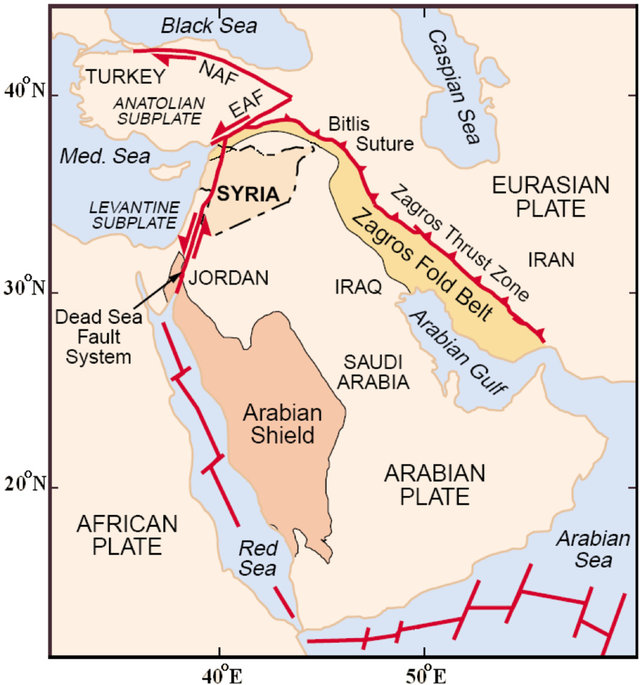
08/02/2023 - Tectonics
08/02/2023
06/02/2023
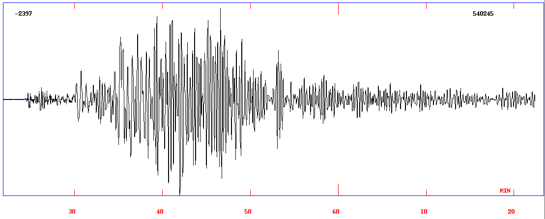
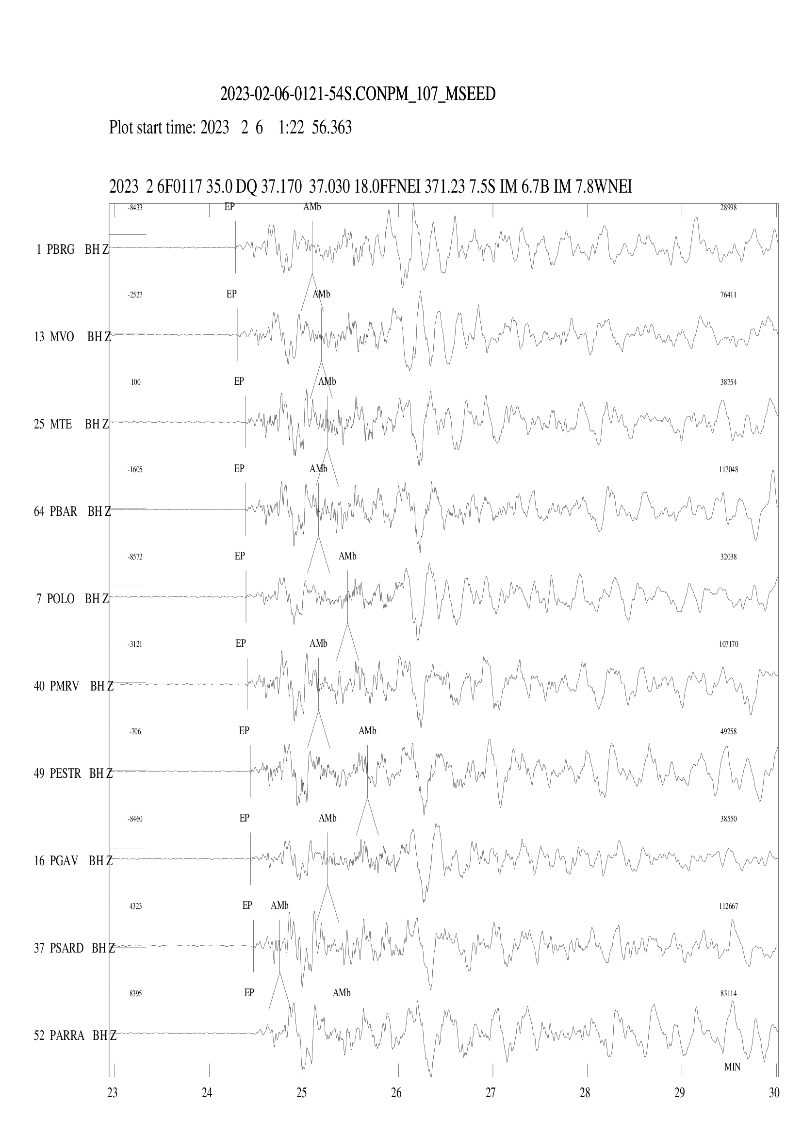
06/02/2023 - Fig. Registration at the Moncorvo seismic station

-
Lisboa:
UTC:
Copyright © Portuguese Institute for Sea and Atmosphere 2026
-
