Instituto Portugues do Mar e Atmosfera - Homepage

  • Who we are | 
  • Where we are | 
  • Scientific Council | 
  • Research | 
  • eLibrary | 
  • ipma encyclopedia  | 
  • Contacts | 
  • Português
  • Weather
    • Weather forecast
    • 10 days and hourly forecast
    • Weather Warnings
    • Meteorological charts
    • Vertical profile
    • Satellite observations
    • Radar
    • Lightning
    • Solar Radiation
    • Online weather stations
    • World forecast
    • Tropical cyclones forecast
    • Report a meteorological phenomenon?
  • Seismic
    • Seismic maps
    • Shakemap
    • Felt an earthquake?
    • Moment Tensor
    • Networks
    • Bulletins
    • Projects
  • Sea
    • Beaches and ports
    • Marine forecast
    • Significant wave height
    • Sea peak period
    • Surface current
    • Sea surface temperature
    • Sea surface height
  • Climate
    • Climate Monitoring
    • Climate Normals
    • Daily monitoring
    • Long data series
    • Monthly monitoring
    • Drought
    • Greenhouse gases
    • Climate Extremes
    • Climate web portal
    • Climate Services
  • Bivalves
    • Bivalves - Situation point
    • Legislation and Documents
    • Production areas
    • Biotoxins
    • Phytoplankton
    • Contaminants Metals
    • Microbiology
    • Bivalves - historical
  • Fisheries
    • Disclosure
    • Projects
    • Fish management
    • ICES
  • Aeronautic
    • TAF and METAR
    • Self Briefing
    • Know more
  • Agriculture
    • Soil Moist Index
    • Vegetation Health Index (VHI)
    • Fraction of Absorbed Radiation (FAPAR)
    • More information
    • Agroclimatic platform
  • Health
    • Ultra-violet index
    • Ozone
    • Pollen
  • Vessels
    • Framework
    • RV Mário Ruivo
    • RV Diplodus
    • Maris
    • Recife II
    • Cardium
  • Space
    • MSG satellite
  • Rural Fires
    • Mainland Rural Fire Danger
    • Madeira Rural Fire Danger
    • Reports Rural Fire Danger
IPMA>Media Center>News

New Satellite JASON-3

JASON2016-01-19 (IPMA)

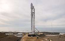
JASON-3 was successfully launched from Vandenberg Air Force Base in California on 17 January. It is the most recent of its series, allowing the estimation of sea-surface height to within a few centimetres. JASON-3 targets a wide range of applications in Meteorology, Oceanography and Climate Monitoring.

The Jason missions are equipped with radar altimetry sensors, the only instrument capable of observing the topography of the ocean surface. JASON-3 will provide global coverage every 10-days. Sea-surface topography provides insight on ocean currents, while in the long-term, sea level constitutes an important indicator of Climate Change. JASON-3 will therefore ensure the continuity of global mean sea level height initiated by Topex-Poseidon in 1992.

JASON-3 is a joint US-European project, involving: EUMETSAT, the European agency for the exploitation of meteorological satellites; CNES, the French space agency; and US agencies NOAA and NASA.

Further information at:
http://www.eumetsat.int/website/home/Satellites/FutureSatellites/CopernicusSatellites/Jason3/index.html

 
  • Figura 1 – Image from JASON-3
  • Figura 2 – Image from launch area
 

Media Center

  • Entrance Media Center
  • News
    • 2025
    • 2024
    • 2023
    • 2022
    • 2021
    • 2020
    • 2019
    • 2018
    • 2017
    • 2016
    • 2015
    • 2014
    • 2013
    • 2012
  • Press Releases
  • Multimedia
  • Disclosures

Follow us on

  • icon facebook Facebook
  • icon twitter Twitter
  • icon youtube Youtube
  • icon Educast IPMA Educast


  • Media

    • News
    • Communiqué
    • Lectures / workshops
    • YouTube
    • IPMA on Educast
  • Social network

    • Facebook
    • Facebook - Azores
    • Twitter
    • Instagram
  • Services

    • Products and services
    • RSS
    • Apps Android
    • Apps Apple
    • PDA
  • Information

    • Contact
    • Useful links
    • Research scholarship
    • EEAGrants projects
    • ECMWF
  • About site

    • Accessibility
    • Legal warnings
    • Site Map
  • Web projects

    • Observar
    • Subscriptions
    • Survey
    • E-learning
    • Shakemap
 
  • Apcer - A marca da Certificação
  • Lisboa:
        UTC:

    Copyright © Portuguese Institute for Sea and Atmosphere 2025
  • Ministério da Economia Ministério Agricultura e Pescas