Instituto Portugues do Mar e Atmosfera - Homepage

  • Who we are | 
  • Where we are | 
  • Scientific Council | 
  • Research | 
  • eLibrary | 
  • ipma encyclopedia  | 
  • Contacts | 
  • Português
  • Weather
    • Weather forecast
    • 10 days and hourly forecast
    • Weather Warnings
    • Meteorological charts
    • Vertical profile
    • Satellite observations
    • Radar
    • Lightning
    • Solar Radiation
    • Online weather stations
    • World forecast
    • Tropical cyclones forecast
    • Report a meteorological phenomenon?
  • Seismic
    • Seismic maps
    • Shakemap
    • Felt an earthquake?
    • Moment Tensor
    • Networks
    • Bulletins
    • Projects
  • Sea
    • Beaches and ports
    • Marine forecast
    • Significant wave height
    • Sea peak period
    • Surface current
    • Sea surface temperature
    • Sea surface height
  • Climate
    • Climate Monitoring
    • Climate Normals
    • Daily monitoring
    • Long data series
    • Monthly monitoring
    • Drought
    • Greenhouse gases
    • Climate Extremes
    • Climate web portal
    • Climate Services
  • Bivalves
    • Bivalves - Situation point
    • Legislation and Documents
    • Production areas
    • Biotoxins
    • Phytoplankton
    • Contaminants Metals
    • Microbiology
    • Bivalves - historical
  • Fisheries
    • Disclosure
    • Projects
    • Fish management
    • ICES
  • Aeronautic
    • TAF and METAR
    • Self Briefing
    • Know more
  • Agriculture
    • Soil Moist Index
    • Vegetation Health Index (VHI)
    • Fraction of Absorbed Radiation (FAPAR)
    • More information
    • Agroclimatic platform
  • Health
    • Ultra-violet index
    • Ozone
    • Pollen
  • Vessels
    • Framework
    • RV Mário Ruivo
    • RV Diplodus
    • Maris
    • Recife II
    • Cardium
  • Space
    • MSG satellite
  • Rural Fires
    • Mainland Rural Fire Danger
    • Madeira Rural Fire Danger
    • Reports Rural Fire Danger
IPMA>Media Center>News

Unusual snowfall on Portugal mainland: 26-27 February 2016

snowfall2016-03-03 (IPMA)

Between 24 and 26 February 2016 a strong westerly flow affected Portugal mainland, with the passage of frontal systems producing precipitation, especially to the north of Montejunto-Estrela mountain system. Snowfall affected regions higher than 600 meters on February 26. On February 27, in post-frontal cold air, a strong northwest flow originated snowfall in even lower quotas and unusual places.

Figure 1 identifies snow on the ground, in cyan, on the mountains of Peneda, Gerês, Larouco, Alvão, Marão, Montemuro, Freita, Caramulo, Estrela and Lousã. The top image was obtained on February 29, two days after the event, when the absence of clouds allowed a wide observation of the surface. The bottom image was obtained on March 1, with a notable reduction of the area covered with snow in the regions where snow is unusual.

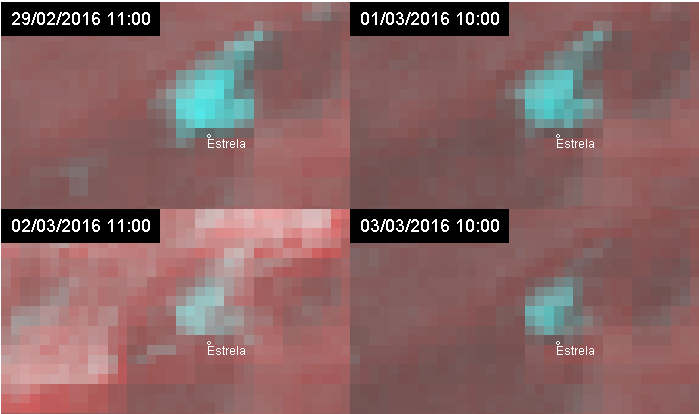
In IPMA´s weather station of Penhas Douradas, at an altitude of 1380 meters, a layer of 15 cm of snow depth was measured on the ground on February 27. On February 29, there was still 12 cm of snow depth and on March 2, there was 5 cm of snow depth. The progressive reduction of the area covered with snow in the Estrela mountain is also identifiable in Figure 2, with images obtained at 10am local time on February 29 and March 1, 2 and 3.

The reports presented by media and on the voluntary cooperation platform of IPMA, METOGLOBAL, and on weather forums in the internet suggest that snowfall has occurred in altitudes down to 300 meters, following IPMA´s forecasts in previous days, in particular in mountains as Monchique, Aire, Candeeiros and Montejunto, or in places like Fátima, Leiria, Sobral de Montagraço and Arraiolos.

Figure 1 - Combined images, at 10am local time, from a Meteosat Second Generation satellite, using a near infrared band (1.6 micron) and a high resolution visible band. Snow on the ground in cyan shades. On top - February 29, 2016 ; below - March 1, 2016 .

Figure 2 - Combined images, at 10am local time, from a Meteosat Second Generation satellite, using a near infrared band (1.6 micron) and a high resolution visible band. Snow on the ground in cyan shades. In sequence from left to right, and top to bottom - February 29 , 1, 2 and 3 March 2016 .

 
  • Figure 1
  • Figure 2
 

Media Center

  • Entrance Media Center
  • News
    • 2025
    • 2024
    • 2023
    • 2022
    • 2021
    • 2020
    • 2019
    • 2018
    • 2017
    • 2016
    • 2015
    • 2014
    • 2013
    • 2012
  • Press Releases
  • Multimedia
  • Disclosures

Follow us on

  • icon facebook Facebook
  • icon twitter Twitter
  • icon youtube Youtube
  • icon Educast IPMA Educast


  • Media

    • News
    • Communiqué
    • Lectures / workshops
    • YouTube
    • IPMA on Educast
  • Social network

    • Facebook
    • Facebook - Azores
    • Twitter
    • Instagram
  • Services

    • Products and services
    • RSS
    • Apps Android
    • Apps Apple
    • PDA
  • Information

    • Contact
    • Useful links
    • Research scholarship
    • EEAGrants projects
    • ECMWF
  • About site

    • Accessibility
    • Legal warnings
    • Site Map
  • Web projects

    • Observar
    • Subscriptions
    • Survey
    • E-learning
    • Shakemap
 
  • Apcer - A marca da Certificação
  • Lisboa:
    01h57m
        UTC:
    0h57m

    Copyright © Portuguese Institute for Sea and Atmosphere 2025
  • Ministério da Economia Ministério Agricultura e Pescas