Instituto Portugues do Mar e Atmosfera - Homepage

  • Who we are | 
  • Where we are | 
  • Scientific Council | 
  • Research | 
  • eLibrary | 
  • ipma encyclopedia  | 
  • Contacts | 
  • Português
  • Weather
    • Weather forecast
    • 10 days and hourly forecast
    • Weather Warnings
    • Meteorological charts
    • Vertical profile
    • Satellite observations
    • Radar
    • Lightning
    • Solar Radiation
    • Online weather stations
    • World forecast
    • Tropical cyclones forecast
    • Report a meteorological phenomenon?
  • Seismic
    • Seismic maps
    • Shakemap
    • Felt an earthquake?
    • Moment Tensor
    • Networks
    • Bulletins
    • Projects
  • Sea
    • Beaches and ports
    • Marine forecast
    • Significant wave height
    • Sea peak period
    • Surface current
    • Sea surface temperature
    • Sea surface height
  • Climate
    • Climate Monitoring
    • Climate Normals
    • Daily monitoring
    • Long data series
    • Monthly monitoring
    • Drought
    • Greenhouse gases
    • Climate Extremes
    • Climate web portal
    • Climate Services
  • Bivalves
    • Bivalves - Situation point
    • Legislation and Documents
    • Production areas
    • Biotoxins
    • Phytoplankton
    • Contaminants Metals
    • Microbiology
    • Bivalves - historical
  • Fisheries
    • Disclosure
    • Projects
    • Fish management
    • ICES
  • Aeronautic
    • TAF and METAR
    • Self Briefing
    • Know more
  • Agriculture
    • Soil Moist Index
    • Vegetation Health Index (VHI)
    • Fraction of Absorbed Radiation (FAPAR)
    • More information
    • Agroclimatic platform
  • Health
    • Ultra-violet index
    • Ozone
    • Pollen
  • Vessels
    • Framework
    • RV Mário Ruivo
    • RV Diplodus
    • Maris
    • Recife II
    • Cardium
  • Space
    • MSG satellite
  • Rural Fires
    • Mainland Rural Fire Danger
    • Madeira Rural Fire Danger
    • Reports Rural Fire Danger
IPMA>Media Center>News

IPMA make available software, which allows to make quick estimates of macroseismic effects in case of an earthquake

shakemap2014-01-22 (IPMA)

In 2013 it was adapted and integrated,in the seismic monitoring system of the Portuguese Sea and Atmosphere Institute, IP, a new version of the ShakeMap software, which allows to make quick estimates of macroseismic effects in case of an earthquake.

This computer application receives and processes instrumental measurements from the national seismic network stations as well as macroseismic information that is generally possible to obtain. Noted that in addition to the national seismic network, the IPMA also processes data from several other nearby seismic stations belonging to agencies from neighbor countries.

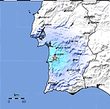
The main products generated by ShakeMap are maps of spatial distribution of ground motion and seismic intensity after the occurrence of an earthquake. These maps provide important information for planning of emergency response and public information.

From the several products generated by ShakeMap, it can be highlighted the map of seismic intensity distribution that uses a color code to show the expected severity of the seismic shaking, allowing rapid identification of the potentially most affected regions.

The ShakeMap can also be used as a tool to generate ground motion scenarios for hypothetical strong earthquakes.

This system is in operation for earthquakes located nearby Portugal mainland and Madeira archipelago, and should be implemented , soon, for the Azores archipelago.

Also note that from today such information becomes available to the general public on the website of IPMA ( http://www.ipma.pt ) and can also be accessed directly at http://shakemap.ipma.pt.

 
  • See shakemap »»
 

Media Center

  • Entrance Media Center
  • News
    • 2025
    • 2024
    • 2023
    • 2022
    • 2021
    • 2020
    • 2019
    • 2018
    • 2017
    • 2016
    • 2015
    • 2014
    • 2013
    • 2012
  • Press Releases
  • Multimedia
  • Disclosures

Follow us on

  • icon facebook Facebook
  • icon twitter Twitter
  • icon youtube Youtube
  • icon Educast IPMA Educast


  • Media

    • News
    • Communiqué
    • Lectures / workshops
    • YouTube
    • IPMA on Educast
  • Social network

    • Facebook
    • Facebook - Azores
    • Twitter
    • Instagram
  • Services

    • Products and services
    • RSS
    • Apps Android
    • Apps Apple
    • PDA
  • Information

    • Contact
    • Useful links
    • Research scholarship
    • EEAGrants projects
    • ECMWF
  • About site

    • Accessibility
    • Legal warnings
    • Site Map
  • Web projects

    • Observar
    • Subscriptions
    • Survey
    • E-learning
    • Shakemap
 
  • Apcer - A marca da Certificação
  • Lisboa:
        UTC:

    Copyright © Portuguese Institute for Sea and Atmosphere 2025
  • Ministério da Economia Ministério Agricultura e Pescas