Instituto Portugues do Mar e Atmosfera - Homepage

  • Who we are | 
  • Where we are | 
  • Scientific Council | 
  • Research | 
  • eLibrary | 
  • ipma encyclopedia  | 
  • Contacts | 
  • Português
  • Weather
    • Weather forecast
    • 10 days and hourly forecast
    • Weather Warnings
    • Meteorological charts
    • Vertical profile
    • Satellite observations
    • Radar
    • Lightning
    • Solar Radiation
    • Online weather stations
    • World forecast
    • Tropical cyclones forecast
    • Report a meteorological phenomenon?
  • Seismic
    • Seismic maps
    • Shakemap
    • Felt an earthquake?
    • Moment Tensor
    • Networks
    • Bulletins
    • Projects
  • Sea
    • Beaches and ports
    • Marine forecast
    • Significant wave height
    • Sea peak period
    • Surface current
    • Sea surface temperature
    • Sea surface height
  • Climate
    • Climate Monitoring
    • Climate Normals
    • Daily monitoring
    • Long data series
    • Monthly monitoring
    • Drought
    • Greenhouse gases
    • Climate Extremes
    • Climate web portal
    • Climate Services
  • Bivalves
    • Bivalves - Situation point
    • Legislation and Documents
    • Production areas
    • Biotoxins
    • Phytoplankton
    • Contaminants Metals
    • Microbiology
    • Bivalves - historical
  • Fisheries
    • Disclosure
    • Projects
    • Fish management
    • ICES
  • Aeronautic
    • TAF and METAR
    • Self Briefing
    • Know more
  • Agriculture
    • Soil Moist Index
    • Vegetation Health Index (VHI)
    • Fraction of Absorbed Radiation (FAPAR)
    • More information
    • Agroclimatic platform
  • Health
    • Ultra-violet index
    • Ozone
    • Pollen
  • Vessels
    • Framework
    • RV Mário Ruivo
    • RV Diplodus
    • Maris
    • Recife II
    • Cardium
  • Space
    • MSG satellite
  • Rural Fires
    • Mainland Rural Fire Danger
    • Madeira Rural Fire Danger
    • Reports Rural Fire Danger
IPMA>Media Center>News

Seismic activity in the Caribbean Sea

shakemap2018-01-10 (IPMA)

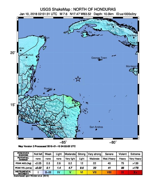
At 02:51 UTC on January 10, 2018 an earthquake occurred in the Caribbean Sea of magnitude 7.6 Mw, about 200km northeast of the coast of Honduras, at a depth of 10 km. This event resulted from a oblique-slip failure (USGS source).

According to the USGS shakemap (see figure), the earthquake was sensed with a maximum intensity of V on the Modified Mercalli scale, which corresponds to a moderate level of vibration and correlated with possible very slight damages. So far there are no reports of casualties or property damage.

Authorities activated tsunami alerts that later were lifted.

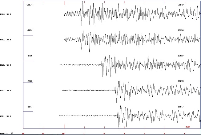
This earthquake was detected in the stations of the national seismic network, with the first waves of the earthquake being recorded at 03:00 in the Azores, 03:01 in Madeira and 03:02 in the mainland stations.


Imagens associadas

  • seismic activity

    seismic activity


Media Center

  • Entrance Media Center
  • News
    • 2025
    • 2024
    • 2023
    • 2022
    • 2021
    • 2020
    • 2019
    • 2018
    • 2017
    • 2016
    • 2015
    • 2014
    • 2013
    • 2012
  • Press Releases
  • Multimedia
  • Disclosures

Follow us on

  • icon facebook Facebook
  • icon twitter Twitter
  • icon youtube Youtube
  • icon Educast IPMA Educast


  • Media

    • News
    • Communiqué
    • Lectures / workshops
    • YouTube
    • IPMA on Educast
  • Social network

    • Facebook
    • Facebook - Azores
    • Twitter
    • Instagram
  • Services

    • Products and services
    • RSS
    • Apps Android
    • Apps Apple
    • PDA
  • Information

    • Contact
    • Useful links
    • Research scholarship
    • EEAGrants projects
    • ECMWF
  • About site

    • Accessibility
    • Legal warnings
    • Site Map
  • Web projects

    • Observar
    • Subscriptions
    • Survey
    • E-learning
    • Shakemap
 
  • Apcer - A marca da Certificação
  • Lisboa:
        UTC:

    Copyright © Portuguese Institute for Sea and Atmosphere 2025
  • Ministério da Economia Ministério Agricultura e Pescas