Instituto Portugues do Mar e Atmosfera - Homepage

  • Who we are | 
  • Where we are | 
  • Scientific Council | 
  • Research | 
  • eLibrary | 
  • ipma encyclopedia  | 
  • Contacts | 
  • Português
  • Weather
    • Weather forecast
    • 10 days and hourly forecast
    • Weather Warnings
    • Meteorological charts
    • Vertical profile
    • Satellite observations
    • Radar
    • Lightning
    • Solar Radiation
    • Online weather stations
    • World forecast
    • Tropical cyclones forecast
    • Report a meteorological phenomenon?
  • Seismic
    • Seismic maps
    • Shakemap
    • Felt an earthquake?
    • Moment Tensor
    • Networks
    • Bulletins
    • Projects
  • Sea
    • Beaches and ports
    • Marine forecast
    • Significant wave height
    • Sea peak period
    • Surface current
    • Sea surface temperature
    • Sea surface height
  • Climate
    • Climate Monitoring
    • Climate Normals
    • Daily monitoring
    • Long data series
    • Monthly monitoring
    • Drought
    • Greenhouse gases
    • Climate Extremes
    • Climate web portal
    • Climate Services
  • Bivalves
    • Bivalves - Situation point
    • Legislation and Documents
    • Production areas
    • Biotoxins
    • Phytoplankton
    • Contaminants Metals
    • Microbiology
    • Bivalves - historical
  • Fisheries
    • Disclosure
    • Projects
    • Fish management
    • ICES
  • Aeronautic
    • TAF and METAR
    • Self Briefing
    • Know more
  • Agriculture
    • Soil Moist Index
    • Vegetation Health Index (VHI)
    • Fraction of Absorbed Radiation (FAPAR)
    • More information
    • Agroclimatic platform
  • Health
    • Ultra-violet index
    • Ozone
    • Pollen
  • Vessels
    • Framework
    • RV Mário Ruivo
    • RV Diplodus
    • Maris
    • Recife II
    • Cardium
  • Space
    • MSG satellite
  • Rural Fires
    • Mainland Rural Fire Danger
    • Madeira Rural Fire Danger
    • Reports Rural Fire Danger
IPMA>Media Center>News

Information about Extra-Tropical Storm Stephanie

stephanie2014-02-11 (IPMA)

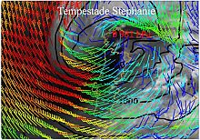
During the evening february 8 and february 9, 2014, a low pressure system crossed the North Atlantic between the East Coast of the USA and the Azores Island, deepening 29 hPa in 24h (between 081200UTC and 091200UTC) and reached the West Cost of Iberian Península with 981 hPa, at 18UTC february 9. This Low was baptized as Stephanie by University of Berlin (Fig. 1).

This low caused heavy precipitation, special in west regions of mainland Portugal, and strong westerly wind during the afternoon and evening february 9, with very strong gusts, reaching 134 km/h in Cabo da Roca.

During the night February 9, the low move to Biscay Gulf, and the wind became northwest and gradually decreased its intensity, but with gusts up to about 80 to 90 km/h, until the evening morning, february 10.

Instituto Hidrográfico (IH) buoys, in Leixões and Sines, in the west portuguese coast, recordeds waves with 8 metres of significant wave high (SWH) 12.5 metres of maximum wave hight (Hmax) in Leixões and 17 metres in Sines, and 10 s of wave mean period (Fig. 2).

The numerical models and operational forecast from IPMA (Fig. 3) agreed with the observations the Instituto Hidrográfico (IH) buoys.

The 17metres Hmax value observed in Sines, can be defined as a “freak (or rogue) wave”, as these value is more than two times the SWH values being an extreme phenomenon, with a probability below 1%.

This situation is very similar to the one occurred in the January 6, associated to Christina Storm. However in that case, the waves were formed in Christina´s Atlantic path, producing waves with similar significant high to the Stephanie but with higher wavelength and periods, therefore more energetic.

 
  • Figure 1- Water Vapour 6.2 micra Satellite Image from MSG, 2014Feb09 at 18UTC, Forecast H+18 ECMWF model 2014Feb09 00UTC run, mean sea level pressure (5 by 5 hPa, black), 10m wind (kt).
  • Table 1 – Maximum gust between february 9 00UTC and 10 06UTC.
  • Figure 2 – Significant Wave Hight (m) and Maximum Wave Hight (m) recorded in Instituto Hidrográfico, IH, buoys (a) Leixões, (b) Sines.
  • Figure 3 –H+24 forecast for the SWAN model 00UTC run, february 10, SWH (Color) and mean waves direction (arrows).
 

Media Center

  • Entrance Media Center
  • News
    • 2025
    • 2024
    • 2023
    • 2022
    • 2021
    • 2020
    • 2019
    • 2018
    • 2017
    • 2016
    • 2015
    • 2014
    • 2013
    • 2012
  • Press Releases
  • Multimedia
  • Disclosures

Follow us on

  • icon facebook Facebook
  • icon twitter Twitter
  • icon youtube Youtube
  • icon Educast IPMA Educast


  • Media

    • News
    • Communiqué
    • Lectures / workshops
    • YouTube
    • IPMA on Educast
  • Social network

    • Facebook
    • Facebook - Azores
    • Twitter
    • Instagram
  • Services

    • Products and services
    • RSS
    • Apps Android
    • Apps Apple
    • PDA
  • Information

    • Contact
    • Useful links
    • Research scholarship
    • EEAGrants projects
    • ECMWF
  • About site

    • Accessibility
    • Legal warnings
    • Site Map
  • Web projects

    • Observar
    • Subscriptions
    • Survey
    • E-learning
    • Shakemap
 
  • Apcer - A marca da Certificação
  • Lisboa:
        UTC:

    Copyright © Portuguese Institute for Sea and Atmosphere 2025
  • Ministério da Economia Ministério Agricultura e Pescas