Instituto Portugues do Mar e Atmosfera - Homepage

  • Who we are | 
  • Where we are | 
  • Scientific Council | 
  • Research | 
  • eLibrary | 
  • ipma encyclopedia  | 
  • Contacts | 
  • Português
  • Weather
    • Weather forecast
    • 10 days and hourly forecast
    • Weather Warnings
    • Meteorological charts
    • Vertical profile
    • Satellite observations
    • Radar
    • Lightning
    • Solar Radiation
    • Online weather stations
    • World forecast
    • Tropical cyclones forecast
    • Report a meteorological phenomenon?
  • Seismic
    • Seismic maps
    • Shakemap
    • Felt an earthquake?
    • Moment Tensor
    • Networks
    • Bulletins
    • Projects
  • Sea
    • Beaches and ports
    • Marine forecast
    • Significant wave height
    • Sea peak period
    • Surface current
    • Sea surface temperature
    • Sea surface height
  • Climate
    • Climate Monitoring
    • Climate Normals
    • Daily monitoring
    • Long data series
    • Monthly monitoring
    • Drought
    • Greenhouse gases
    • Climate Extremes
    • Climate web portal
    • Climate Services
  • Bivalves
    • Bivalves - Situation point
    • Legislation and Documents
    • Production areas
    • Biotoxins
    • Phytoplankton
    • Contaminants Metals
    • Microbiology
    • Bivalves - historical
  • Fisheries
    • Disclosure
    • Projects
    • Fish management
    • ICES
  • Aeronautic
    • TAF and METAR
    • Self Briefing
    • Know more
  • Agriculture
    • Soil Moist Index
    • Vegetation Health Index (VHI)
    • Fraction of Absorbed Radiation (FAPAR)
    • More information
    • Agroclimatic platform
  • Health
    • Ultra-violet index
    • Ozone
    • Pollen
  • Vessels
    • Framework
    • RV Mário Ruivo
    • RV Diplodus
    • Maris
    • Recife II
    • Cardium
  • Space
    • MSG satellite
  • Rural Fires
    • Mainland Rural Fire Danger
    • Madeira Rural Fire Danger
    • Reports Rural Fire Danger
IPMA>Media Center>News

Courelinhas Tornado (Coruche municipality), 13th November 2014

Radar Image Courelinhas2014-11-18 (IPMA)

Regarding the strong wind episode referred in the statement posted on the 14th November 2014 at the IPMA homepage, it was possible to gather more relevant evidence concerning the observed destruction and affected locations.

The nature of the locally observed damage on trees and buildings is compatible with the occurrence of a tornado. According to the diagnosed damage path, the tornado vortex maintained contact with the ground along, at least, 3 km, for a total estimated period between 2:30 and 3:00 minutes, just before 20 UTC.

Given the propagation speed of the parent cloud, it is estimated that the tornado has affected each location just for a few seconds. Courelinhas was located right within the tornado damage path. Widespread damage to trees, some big branches twisted or snapped off, some of the bigger trees snapped or uprooted, some weak outbuildings destroyed and some heavier debris carried airborne at considerable distance, allowed to classify the Courelinhas tornado as an F1/T3 tornado, according to the joint use of the Fujita (F) and Torro (T) scales. This corresponds to an estimation of the maximum instantaneous wind (gust, 3s) in the range between 42 m/s and 51 m/s or between about 151 km/h and 184 km/h.

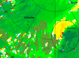
Doppler radar observations of the Coruche/Cruz do Leão radar allowed the identification of the supercell structure type to which the tornado was associated with. The mesocyclone corresponding to this supercell is visible in the image, by 19:56 UTC.

 
  • Radar image 19:56 UTC
 

Media Center

  • Entrance Media Center
  • News
    • 2025
    • 2024
    • 2023
    • 2022
    • 2021
    • 2020
    • 2019
    • 2018
    • 2017
    • 2016
    • 2015
    • 2014
    • 2013
    • 2012
  • Press Releases
  • Multimedia
  • Disclosures

Follow us on

  • icon facebook Facebook
  • icon twitter Twitter
  • icon youtube Youtube
  • icon Educast IPMA Educast


  • Media

    • News
    • Communiqué
    • Lectures / workshops
    • YouTube
    • IPMA on Educast
  • Social network

    • Facebook
    • Facebook - Azores
    • Twitter
    • Instagram
  • Services

    • Products and services
    • RSS
    • Apps Android
    • Apps Apple
    • PDA
  • Information

    • Contact
    • Useful links
    • Research scholarship
    • EEAGrants projects
    • ECMWF
  • About site

    • Accessibility
    • Legal warnings
    • Site Map
  • Web projects

    • Observar
    • Subscriptions
    • Survey
    • E-learning
    • Shakemap
 
  • Apcer - A marca da Certificação
  • Lisboa:
    00h53m
        UTC:
    23h53m

    Copyright © Portuguese Institute for Sea and Atmosphere 2025
  • Ministério da Economia Ministério Agricultura e Pescas