Select RADAR product
- Portugal dynamic map
- Azores dynamic map
- Madeira dynamic map
- RADAR Images
Capture
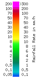
Precipitation intensity (mm/h)
Information
Important
The data available should only be use for information. It cannot be use for official issues.
We make only available the today (hourly updated) and yesterday data.
Reference hour used is UTC.
Radar - Portugal dynamic map [Precipitation intensity (mm/h)]

-
Lisboa:
UTC:
Copyright © Portuguese Institute for Sea and Atmosphere 2026
-
