Instituto Portugues do Mar e Atmosfera - Homepage

  • Who we are | 
  • Where we are | 
  • Scientific Council | 
  • Research | 
  • eLibrary | 
  • ipma encyclopedia  | 
  • Contacts | 
  • Português
  • Weather
    • Weather forecast
    • 10 days and hourly forecast
    • Weather Warnings
    • Meteorological charts
    • Vertical profile
    • Satellite observations
    • Radar
    • Lightning
    • Solar Radiation
    • Online weather stations
    • World forecast
    • Tropical cyclones forecast
    • Report a meteorological phenomenon?
  • Seismic
    • Seismic maps
    • Shakemap
    • Felt an earthquake?
    • Moment Tensor
    • Networks
    • Bulletins
    • Projects
  • Sea
    • Beaches and ports
    • Marine forecast
    • Significant wave height
    • Sea peak period
    • Surface current
    • Sea surface temperature
    • Sea surface height
  • Climate
    • Climate Monitoring
    • Climate Normals
    • Daily monitoring
    • Long data series
    • Monthly monitoring
    • Drought
    • Greenhouse gases
    • Climate Extremes
    • Climate web portal
    • Climate Services
  • Bivalves
    • Bivalves - Situation point
    • Legislation and Documents
    • Production areas
    • Biotoxins
    • Phytoplankton
    • Contaminants Metals
    • Microbiology
    • Bivalves - historical
  • Fisheries
    • Disclosure
    • Projects
    • Fish management
    • ICES
  • Aeronautic
    • TAF and METAR
    • Self Briefing
    • Know more
  • Agriculture
    • Soil Moist Index
    • Vegetation Health Index (VHI)
    • Fraction of Absorbed Radiation (FAPAR)
    • More information
    • Agroclimatic platform
  • Health
    • Ultra-violet index
    • Ozone
    • Pollen
    • Air temperature
  • Vessels
    • Framework
    • RV Mário Ruivo
    • RV Diplodus
    • Maris
    • Recife II
    • Cardium
  • Space
    • MSG satellite
  • Rural Fires
    • Mainland Rural Fire Danger
    • Madeira Rural Fire Danger
    • Reports Rural Fire Danger

News

  • 1st Meeting GOOS/EOOS

    EOOS logo European Ocean Observing System
    Mon May 05 09:00:00 UTC 2025
  • Diplodus in Total Requalification

    Total Requalification of IPMA Vessel Total Requalification of IPMA Vessel
    Fri May 02 09:00:00 UTC 2025
  • Iberian Symposium SIMERPE 3

    SIMERPE 3 Symposium on the Evaluation of Fisheries Resources
    Fri May 02 09:00:00 UTC 2025
  • More news
IPMA>Services

See More

  • Data
  • Thecnical advice
  • Laboratory analises
  • Formation
  • Selfbriefing
  • meteoglobal
  • Meteoglobal
  • Sistema Subscrições
  • APP MOBILE - meteo
  • App Mobile - seismic
  • App mobile - gelavista (new)
  • rss

See More - Daily gridded precipitation dataset over mainland Portugal

Data description

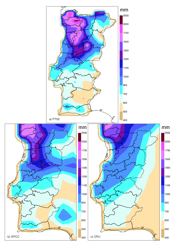
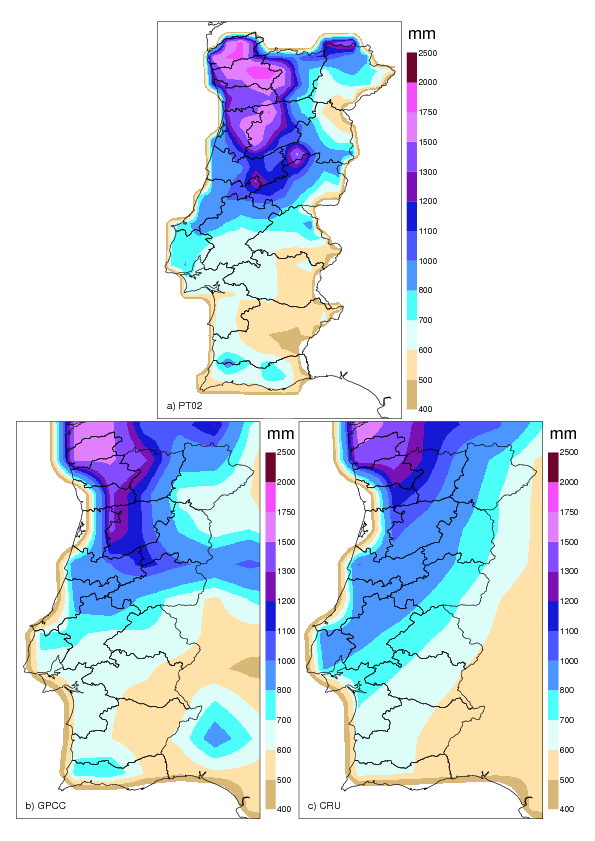
The dataset PT02 is a new high resolution (0.2°×0.2°) daily gridded precipitation dataset over mainland Portugal. This dataset spans the period from 1950 to 2003 and is based on 806 stations, 188 meteorological stations from Portuguese Meteorological Service (IM) and 618 rain gauges from the National Water Institute (INAG). Most of these (726) stations have at least 10 years of data.

The interpolation method applied to create the PT02 dataset was the ordinary kriging, which was compared with simpler techniques, namely, inverse distance weighting methods.

This dataset was used to evaluate four global gridded datasets: two based on rain gauges (Climate Research Unit (CRU) and Global Precipitation Climate Center (GPCC)) and two ECMWF re-analyses (ERA-40 and ERA-Interim). A detailed description about PT02 and about the comparison with other datasets is presented in the paper:

  • Belo-Pereira, M., E. Dutra, and P. Viterbo, 2011: Evaluation of global precipitation data sets over the Iberian Peninsula, J. Geophys. Res., 116, D20101, doi:10.1029/2010JD015481. See paper


Terms and conditions of use

Spatial distribution of meteorological stations and/or pluviometric stations in mainland Portugal. 
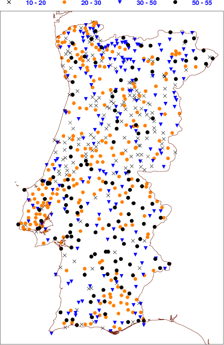
Figure 1 - Spatial distribution of stations over mainland Portugal selected to build the gridded dataset and its temporal coverage (in years), considering a maximum of 30% of missing data. Black circles identify stations with data during more than 50 years. Blue triangles, orange circles, and black crosses represent stations with data between 31 and 50 years, 21 and 30 years, and 10 and 20 years, respectively.

The PT02 dataset was developed by IPMA, I.P. and is distributed freely for non-commercial research and education projects only. For commercial applications you should contact IPMA, I.P. ( info @ ipma.pt ).

Redistribution of data to third parties is not allowed without IPMA, I.P. ´s permission.

Any publications or application using the whole or part of this dataset, should include the following acknowledgments and citation:

  • "The authors thank IPMA, I.P. by the data provided for this work (PT02 gridded precipitation dataset)".
  • Belo-Pereira, M., E. Dutra, and P. Viterbo, 2011: Evaluation of global precipitation data sets over the Iberian Peninsula, J. Geophys. Res., 116, D20101, doi:10.1029/2010JD015481.


Data access

The access to the precipitation data from the dataset PT02 is done by accessing the following links:

  • NetCDF data format
  • ASCII data format

For other purposes and other data will need to contact the IPMA, IP ( info @ ipma.pt ).


PT02 can be completed with the Spain dataset (http://www.meteo.unican.es/es/datasets/spain02) to obtain a precipitation dataset covering the Iberian Peninsula (IP02).


See the example maps

  • Mean annual precipitation over Portugal (1961-1990)
    proj CI, prec avg 61-90
  • Mean annual precipitation over Portugal (1971-2000)
    proj CI, prec avg 71-00
 
 
  • Media

    • News
    • Communiqué
    • Lectures / workshops
    • YouTube
    • IPMA on Educast
  • Social network

    • Facebook
    • Facebook - Azores
    • Twitter
    • Instagram
  • Services

    • Products and services
    • RSS
    • Apps Android
    • Apps Apple
    • PDA
  • Information

    • Contact
    • Useful links
    • Research scholarship
    • EEAGrants projects
    • ECMWF
  • About site

    • Accessibility
    • Legal warnings
    • Site Map
  • Web projects

    • Observar
    • Subscriptions
    • Survey
    • E-learning
    • Shakemap
 
  • Apcer - A marca da Certificação
  • Lisboa:
    17h40m
        UTC:
    16h40m

    Copyright © Portuguese Institute for Sea and Atmosphere 2025
  • Ministério da Economia Ministério Agricultura e Pescas