Instituto Portugues do Mar e Atmosfera - Homepage

  • Who we are | 
  • Where we are | 
  • Scientific Council | 
  • Research | 
  • eLibrary | 
  • ipma encyclopedia  | 
  • Contacts | 
  • Português
  • Weather
    • Weather forecast
    • 10 days and hourly forecast
    • Weather Warnings
    • Meteorological charts
    • Vertical profile
    • Satellite observations
    • Radar
    • Lightning
    • Solar Radiation
    • Online weather stations
    • World forecast
    • Tropical cyclones forecast
    • Report a meteorological phenomenon?
  • Seismic
    • Seismic maps
    • Shakemap
    • Felt an earthquake?
    • Moment Tensor
    • Networks
    • Bulletins
    • Projects
  • Sea
    • Beaches and ports
    • Marine forecast
    • Significant wave height
    • Sea peak period
    • Surface current
    • Sea surface temperature
    • Sea surface height
  • Climate
    • Climate Monitoring
    • Climate Normals
    • Daily monitoring
    • Long data series
    • Monthly monitoring
    • Drought
    • Greenhouse gases
    • Climate Extremes
    • Climate web portal
    • Climate Services
  • Bivalves
    • Bivalves - Situation point
    • Legislation and Documents
    • Production areas
    • Biotoxins
    • Phytoplankton
    • Contaminants Metals
    • Microbiology
    • Bivalves - historical
  • Fisheries
    • Disclosure
    • Projects
    • Fish management
    • ICES
  • Aeronautic
    • TAF and METAR
    • Self Briefing
    • Know more
  • Agriculture
    • Soil Moist Index
    • Vegetation Health Index (VHI)
    • Fraction of Absorbed Radiation (FAPAR)
    • More information
    • Agroclimatic platform
  • Health
    • Ultra-violet index
    • Ozone
    • Pollen
    • Air temperature
  • Vessels
    • Framework
    • RV Mário Ruivo
    • RV Diplodus
    • Maris
    • Recife II
    • Cardium
  • Space
    • MSG satellite
  • Rural Fires
    • Mainland Rural Fire Danger
    • Madeira Rural Fire Danger
    • Reports Rural Fire Danger

News

  • 1st Meeting GOOS/EOOS

    EOOS logo European Ocean Observing System
    Mon May 05 09:00:00 UTC 2025
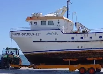
  • Diplodus in Total Requalification

    Total Requalification of IPMA Vessel Total Requalification of IPMA Vessel
    Fri May 02 09:00:00 UTC 2025
  • Iberian Symposium SIMERPE 3

    SIMERPE 3 Symposium on the Evaluation of Fisheries Resources
    Fri May 02 09:00:00 UTC 2025
  • More news
IPMA>Encyclopedia IPMA>Weather>

ALADIN

ALADIN is a numerical weather prediction limited area model (over a specific region of Earth) developed from code ARPEGE/FIS by several numerical prediction groups in Europe and Northern Africa, through the International Project ALADIN, under co-ordination of Météo-France. The ALADIN model was designed to yield predictions up to 48-72 hours ahead with horizontal resolutions between 7 km and 15 km. Thus, ALADIN is more adequate to predict mesoscale-beta phenomena (spatial scales from 20 to 200 km and time scales from 30 minutes to 6 hours), such as breeze winds, mountain winds (anabatic and catabatic winds) and convective phenomena (which can cause showers and/or thunderstorms).

In Portugal, The operational version of ALADIN is performed at a DEC Alpha, with a 48 hours integration period, over a geographic area of approximately 1050 km by 1050 km (figure below) with 31 vertical levels and 12.7 km horizontal resolution.

Horizontal its on essentially depends orography model the of detail.

Main surface parameters: pressure at the surface (ground level), air pressure at mean sea level, air temperature and relative humidity at 2 m, zonal and meridional wind at 10 m, total cloudiness, convective precipitation and large scale precipitation.

Altitude parameters:geopotential, temperature, zonal wind, meridional wind, vertical velocity, relative humidity.

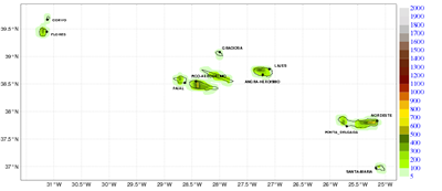
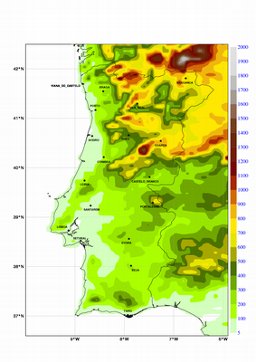
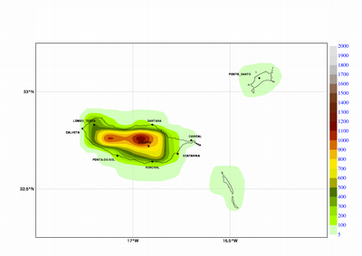
ALADIN orografy
orografia ALADINA çores orografia ALADINContinente
orografia ALADIN Madeira
*Action de Recherche Petite Echelle Grande Echelle/Integrated Forecasting System, a project between Météo-France and ECMWF with the main objectives of developing methods of data assimilation and producing weather prediction models.
 
 
  • Media

    • News
    • Communiqué
    • Lectures / workshops
    • YouTube
    • IPMA on Educast
  • Social network

    • Facebook
    • Facebook - Azores
    • Twitter
    • Instagram
  • Services

    • Products and services
    • RSS
    • Apps Android
    • Apps Apple
    • PDA
  • Information

    • Contact
    • Useful links
    • Research scholarship
    • EEAGrants projects
    • ECMWF
  • About site

    • Accessibility
    • Legal warnings
    • Site Map
  • Web projects

    • Observar
    • Subscriptions
    • Survey
    • E-learning
    • Shakemap
 
  • Apcer - A marca da Certificação
  • Lisboa:
        UTC:

    Copyright © Portuguese Institute for Sea and Atmosphere 2025
  • Ministério da Economia Ministério Agricultura e Pescas