Instituto Portugues do Mar e Atmosfera - Homepage

  • Who we are | 
  • Where we are | 
  • Scientific Council | 
  • Research | 
  • eLibrary | 
  • ipma encyclopedia  | 
  • Contacts | 
  • Português
  • Weather
    • Weather forecast
    • 10 days and hourly forecast
    • Weather Warnings
    • Meteorological charts
    • Vertical profile
    • Satellite observations
    • Radar
    • Lightning
    • Solar Radiation
    • Online weather stations
    • World forecast
    • Tropical cyclones forecast
    • Report a meteorological phenomenon?
  • Seismic
    • Seismic maps
    • Shakemap
    • Felt an earthquake?
    • Moment Tensor
    • Networks
    • Bulletins
    • Projects
  • Sea
    • Beaches and ports
    • Marine forecast
    • Significant wave height
    • Sea peak period
    • Surface current
    • Sea surface temperature
    • Sea surface height
  • Climate
    • Climate Monitoring
    • Climate Normals
    • Daily monitoring
    • Long data series
    • Monthly monitoring
    • Drought
    • Greenhouse gases
    • Climate Extremes
    • Climate web portal
    • Climate Services
  • Bivalves
    • Bivalves - Situation point
    • Legislation and Documents
    • Production areas
    • Biotoxins
    • Phytoplankton
    • Contaminants Metals
    • Microbiology
    • Bivalves - historical
  • Fisheries
    • Disclosure
    • Projects
    • Fish management
    • ICES
  • Aeronautic
    • TAF and METAR
    • Self Briefing
    • Know more
  • Agriculture
    • Soil Moist Index
    • Vegetation Health Index (VHI)
    • Fraction of Absorbed Radiation (FAPAR)
    • More information
    • Agroclimatic platform
  • Health
    • Ultra-violet index
    • Ozone
    • Pollen
    • Air temperature
  • Vessels
    • Framework
    • RV Mário Ruivo
    • RV Diplodus
    • Maris
    • Recife II
    • Cardium
  • Space
    • MSG satellite
  • Rural Fires
    • Mainland Rural Fire Danger
    • Madeira Rural Fire Danger
    • Reports Rural Fire Danger

News

  • 1st Meeting GOOS/EOOS

    EOOS logo European Ocean Observing System
    Mon May 05 09:00:00 UTC 2025
  • Diplodus in Total Requalification

    Total Requalification of IPMA Vessel Total Requalification of IPMA Vessel
    Fri May 02 09:00:00 UTC 2025
  • Iberian Symposium SIMERPE 3

    SIMERPE 3 Symposium on the Evaluation of Fisheries Resources
    Fri May 02 09:00:00 UTC 2025
  • More news
IPMA>Space>msg

Dynamic map - MSG4 satellite

  • Date:
  • MSG-10.8
  • MSG-10.8 - high/cool clouds
  • Composite Air Mass
Logo IPMA

Product Description

MSG-10.8

Images obtained by the SEVIRI sensor onboard the satellite Meteosat geostationary European Second Generation (MSG), corresponding to the thermal infrared channel centered at 10.8 micrometers. In this images brightness temperatures are represented; the higher (warmer) appear in darker shades (corresponding to continental surfaces). The colors from gray to white indicates cloud tops at various altitudes; the highest tops, then cooler appear white.

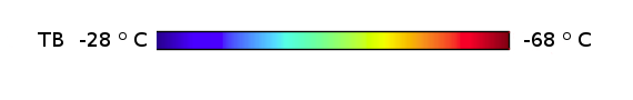
MSG-10.8 - High/cool clouds

Images obtained by the SEVIRI sensor onboard the European geostationary satellite Meteosat Second Generation (MSG), corresponding to the channel thermal infrared, centered on 10.8 micrometers. In these images of brightness temperature are represented; in dark tones arise continental surfaces (warmer). Clouds, with the tops different elevations, are represented in gray scale. Brightness temperatures below -28 º C appear in the color scale of blue to red, indicating large vertical development clouds.

Air mass

Images obtained by the combination of 4 channels in the infrared band of the SEVIRI sensor on board the Meteosat Second Generation (MSG), centered on 6.2 uM, 7.3 uM, 9.7 m and 10.8 micrometers. Are used for example in the discrimination of air masses (warm tropical air with low ozone concentration comes in shades of green, polar air, cold and high concentration of ozone, comes in shades of blue), thick clouds with tops at high levels the atmosphere appear to white and intrusion zones air estatosférico, cyclogenesis indicator, appear in reddish tones.


  • Media

    • News
    • Communiqué
    • Lectures / workshops
    • YouTube
    • IPMA on Educast
  • Social network

    • Facebook
    • Facebook - Azores
    • Twitter
    • Instagram
  • Services

    • Products and services
    • RSS
    • Apps Android
    • Apps Apple
    • PDA
  • Information

    • Contact
    • Useful links
    • Research scholarship
    • EEAGrants projects
    • ECMWF
  • About site

    • Accessibility
    • Legal warnings
    • Site Map
  • Web projects

    • Observar
    • Subscriptions
    • Survey
    • E-learning
    • Shakemap
 
  • Apcer - A marca da Certificação
  • Lisboa:
        UTC:

    Copyright © Portuguese Institute for Sea and Atmosphere 2025
  • Ministério da Economia Ministério Agricultura e Pescas