Instituto Portugues do Mar e Atmosfera - Homepage

  • Who we are | 
  • Where we are | 
  • Scientific Council | 
  • Research | 
  • eLibrary | 
  • ipma encyclopedia  | 
  • Contacts | 
  • Português
  • Weather
    • Weather forecast
    • 10 days and hourly forecast
    • Weather Warnings
    • Meteorological charts
    • Vertical profile
    • Satellite observations
    • Radar
    • Lightning
    • Solar Radiation
    • Online weather stations
    • World forecast
    • Tropical cyclones forecast
    • Report a meteorological phenomenon?
  • Seismic
    • Seismic maps
    • Shakemap
    • Felt an earthquake?
    • Moment Tensor
    • Networks
    • Bulletins
    • Projects
  • Sea
    • Beaches and ports
    • Marine forecast
    • Significant wave height
    • Sea peak period
    • Surface current
    • Sea surface temperature
    • Sea surface height
  • Climate
    • Climate Monitoring
    • Climate Normals
    • Dataclima
    • Daily monitoring
    • Long data series
    • Monthly monitoring
    • Drought
    • NAO & EA Index
    • Greenhouse gases
    • Climate Extremes
    • Climate web portal
    • Climate Services
  • Bivalves
    • Bivalves - Situation point
    • Legislation and Documents
    • Production areas
    • Biotoxins
    • Phytoplankton
    • Contaminants Metals
    • Microbiology
    • Bivalves - historical
  • Fisheries
    • Disclosure
    • Projects
    • Tavira Molusciculture Station
    • Aquaculture Research Center
    • Fish management
    • ICES
  • Aeronautic
    • TAF and METAR
    • Selfbriefing
    • Know more
  • Agriculture
    • Soil Moist Index
    • Vegetation Health Index (VHI)
    • Fraction of Absorbed Radiation (FAPAR)
    • More information
    • Agroclimatic platform
  • Health
    • Ultra-violet index
    • Ozone
    • Pollen
  • Vessels
    • Framework
    • RV Mário Ruivo
    • RV Diplodus
    • Maris
    • Recife II
    • Cardium
  • Space
    • MSG satellite
  • Rural Fires
    • Mainland Rural Fire Danger
    • Madeira Rural Fire Danger
    • Reports Rural Fire Danger

News

  • International gathering in Algés

    Blue Circular Innovation Event
    Fri Sep 11 09:00:00 UTC 2026
  • Technical studies on offshore energy potential

    Publication of the Final Reports for the project
    Mon Sep 07 14:33:00 UTC 2026
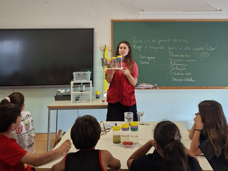
  • Primary school students

    Sessions dedicated to Circular Aquaculture
    Wed Jul 22 09:00:00 UTC 2026
  • More news
IPMA>Encyclopedia IPMA>Maritime

Responsability Areas in the North Atlantic
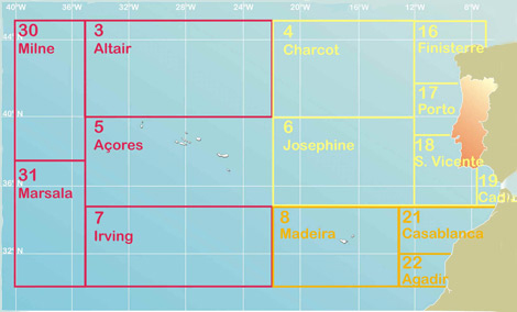
Marine meteorology | Responsability areas | Numeric wave models | Sea state conditions
maritima_zonas_mar

In 1973, norms in the scope of Global Marine Distress Safety System (GMDSS) are established, that contain the weather report for the sea. Recognizing the necessity to optimize, automate and issue (broadcast) this information, World Meteorological Organization (WMO) created the Oceans and the Seas responsibility areas (METAREAS), for which it nominated a National Meteorological Service (NMS) as coordinating. The assignments of the sub-areas of each METAREA come from the topographical characteristics of the oceanic regions (abyssal submarines mounts and fosses) or of the bordering coastal place.
 
 
  • Media

    • News
    • Communiqué
    • Lectures / workshops
    • YouTube
    • IPMA on Educast
  • Social network

    • Facebook
    • Facebook - Azores
    • Twitter
    • Instagram
  • Services

    • Products and services
    • RSS
    • Apps Android
    • Apps Apple
  • Information

    • Contact
    • Useful links
    • Research scholarship
    • EEAGrants projects
    • ECMWF
  • About site

    • Accessibility
    • Legal warnings
    • Site Map
  • Web projects

    • Observar
    • Subscriptions
    • Survey
    • Shakemap
 
  • Apcer - A marca da Certificação
  • Lisboa:
        UTC:

    Copyright © Portuguese Institute for Sea and Atmosphere 2026
  • Ministério da Agricultura e Mar